| BANKFULL
DISCHARGE |
 |
| BANKFULL
DISCHARGE |
|
THE BASIC IDEA
Dynamically stable stream channels formed in fully alluvial materials (sediments
that can be eroded and deposited by the stream) tend to have widths, depths,
and slopes that reflect a balance among the geological and hydrologic variables
that interact to create the fluvial system. Many scientists and engineers have
found the concept of channel-forming discharge to be a useful
tool in understanding and managing streams. This concept is based on the idea
that even though channel width, depth, and slope vary along a stream and through
time, average values of width, depth and slope tend to be constant for a reach
with a given drainage area if:
1. The stream bed and banks are alluvial,
2. There have not been any extreme floods, droughts, earthquakes, forest fires, or other catastrophic events in the recent past,
3. The watershed is largely free of human-caused disturbances, such as land use changes, grazing, mining, road building, dams, or channelization, and4. Furthermore, the channel geometry is such that the greatest discharge the channel will carry without overflowing is not a rare flood (which moves tremendous amounts of sediment, but occurs only rarely) or a low flow (which occurs frequently, but has relatively little erosive power), but is an intermediate magnitude, such as the one- or two-year flood.
This characteristic discharge
is referred to as the “channel-forming” or “dominant” discharge,
Qcf. This discharge therefore dominates channel form and
process, at least for streams in humid regions and for perennial streams in
semi-arid environments (Soar and Thorne, 2001 and
Biedenharn et al., 2001).
Clearly, very few stream reaches meet the four criteria outlined above, and
few can be described as "dynamically stable" or "fully alluvial" without
qualification. Therefore, channel geometries often vary considerably from sizes
needed to convey Qcf. Many workers ignore departures from ideal
conditions, and determine bankfull stage based on field indicators like permanent
vegetation or terraces, but this approach can lead to errors.
SIGNIFICANCE OF Qcf TO PROPOSED CHANNEL
MODIFICATION OR STREAMBANK STABILIZATION
One of the principal reasons for estimating "channel forming discharge"
(or dominant discharge) is to insure that any planned modification to channel
cross section (as a result of proposed bank or channel protection measures along
a reach of stream) will be compatible with this discharge. There are several approaches
that can be employed to estimate this channel forming discharge. Under the right
conditions, other types of flows, including "bankfull discharge," can
be used as surrogates. The characteristics of these flows, their method of
measurement, and their applicability as a surrogate for Qcf is discussed
in the next section.
METHODS FOR DETERMINING Qcf
At least three approaches are available for determining Qcf ; effective
discharge (Qeff), bankfull discharge (Qbf), or the discharge
that corresponds to a given return interval, Qri (Table 1).
Quantitative Estimate of Qcf
|
Data Requirements |
Recommended For |
Limitations |
Effective Discharge (Qeff) |
Historical hydrology for flow duration curve (10 years or more recommended) or synthetic flow duration curve; channel survey; hydraulic analysis; sediment gradation; sediment transport analysis and model calibration (if possible). |
Channel design |
Requires large data set and training in hydraulic
engineering or fluvial geomorpholgy |
Bankfull Discharge (Qbf) |
Channel survey; hydraulic analysis and model calibration
using observed stage-discharge relation (if possible). Identification
of field indicators in a stable, alluvial reach. |
Stability assessment; estimation of Qeff
in stable channels |
Can be very dynamic in unstable channels/watersheds;
field indicators can be misleading |
Return Interval Discharge (Qri) |
Historical hydrology for flood frequency analysis,
regional regression equations, or hydrologic model. |
First approximation of Qeff and/or Qbf
in stable channels |
No physical basis; relations to Qeff and
Qbf inconsistent in literature |
EFFECTIVE DISCHARGE
If available, a time series of discharge records may be used to construct
a frequency histogram. The mass of sediment transported by each discharge
increment may be computed using a sediment rating curve or sediment transport
formula. The effective discharge, Qeff, is the increment of discharge
that transports the largest sediment load over a period of years (Wolman and
Miller, 1960; Andrews, 1980; Emmett & Wolman, 2001). References cited
in the paragraph should be used as guides for performing the necessary computations.
Thus, Qeff integrates the magnitude and frequency of flow events,
and is the best starting point for design because it links sediment load with
channel geometry. However, there are several problems associated with Qeff,
(Biedenharn et al., 2000 and
2001; Soar & Thorne, 2001).
Key among these is the high level of uncertainty in sediment transport computations.
The effective discharge is useful in comparing the competence of alternative
channel geometries to transport the incoming sediment load. Results of effective
discharge analysis are also useful when predicting the impact of alteration
of watershed conditions with respect to sediment loads (e.g., upstream dam
removal) or hydrology (e.g., urbanization) on channel stability.
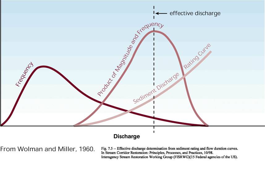
Figure 1. Effective discharge is the maximum of the curve produced by multiplying the flow frequency curve times the sediment transport curve. (From FISRWG 1998).
BANKFULL DISCHARGE
The expression, "bankfull discharge," Qbf, should be
used to refer to the maximum discharge that the channel can convey without
overflow onto the floodplain. Although this definition, proposed by Copeland
et al. (2001),
differs from that used by others (e.g., Rosgen, 1996), it eliminates confusion.
As noted above, theoretically Qbf and Qeff are generally
equivalent in channels that have remained stable for a period of time, thus
allowing the channel morphology to adjust to the current hydrologic and sediment
regime of the watershed (e.g., Pickup, 1976, Andrews, 1980, Soar, 2000, but
see Emmitt & Wolman, 2001). In such a channel, the bankfull discharge
corresponds to a sharp change in the slope of the rating curve (Figure 2).
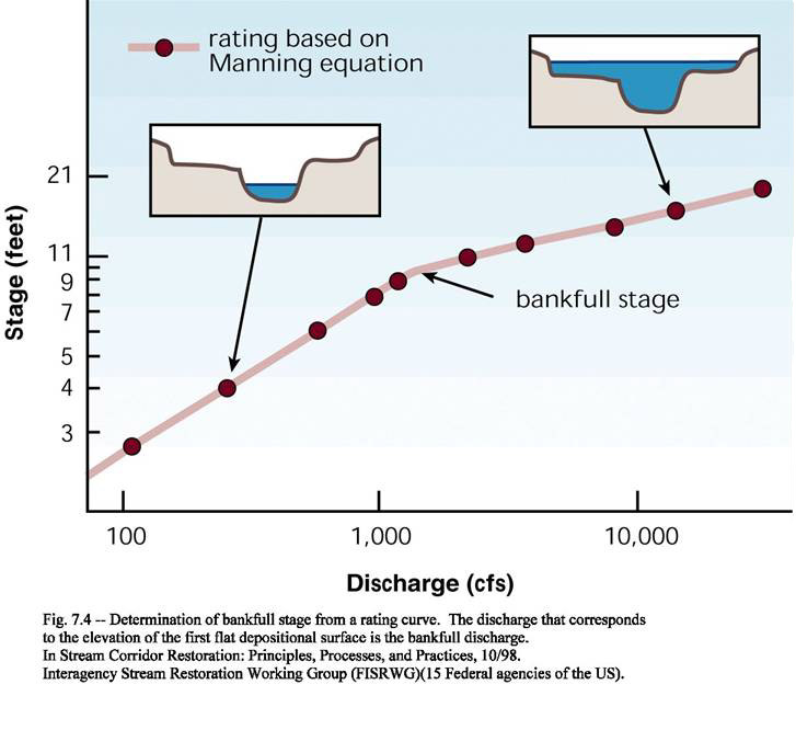
It must be noted, however, that in an unstable channel that is adjusting
its morphology to changes in the hydrologic or sediment regime, Qbf can
vary markedly from Qeff. Therefore, the expression "bankfull
discharge" should never be used to refer to Qri or Qeff.
The relationship of Qbf to Qri and Qeff is
useful as an indicator of channel stability and evolution (Schumm et
al., 1984; Simon, 1989; Thorne et al., 1996). The Qbf from ‘template’
or ‘reference’ reaches (stable reaches from similar watersheds)
has been used as a guideline for relevant dimensions of the restored channel
(Rosgen, 1996). Field indicators of Qbf are often unreliable (Williams,
1978). Problems associated with basing design on Qbf are discussed
by FISRWG (1998)
and Biedenharn et al. (2000).
DISCHARGE FOR A SPECIFIC RETURN INTERVAL,Qri
If gage data are available, the discharge with a given return interval is often
assumed to be the channel-forming discharge, e.g., Qcf = Q2,
where Q2 is the two-year return interval discharge (Hey 1994,
Ministry of Natural Resources 1994, Riley 1998). In general, Qbf
in stable channels corresponds to a flood recurrence interval of approximately
1 to 2.5 years in the partial duration series (Leopold et al., 1964, Andrews,
1980), although intervals outside this range are not uncommon. Recurrence
interval relations are intrinsically different for channels with flashy hydrology
than for those with less variable flows. Because of such discrepancies, many
studies have concluded that recurrence interval approaches tend to generate
poor estimates of Qbf (Williams, 1978, Kondolf et al.,
2001) and of Qeff (Pickup, 1976, Doyle et al., 1999).
Hence, assuming a priori that Qri is related to either Qbf or
Qeff should be avoided, although it may be useful at times to
serve as a first estimate of Qeff and/or Qbf in stable
channels, particularly those with snowmelt hydrology (Doyle et al., 1999).
The Qri approach is based on the assumption of stationary hydrologic
conditions and thus is weak when applied to situations such as urbanizing
watersheds where land use changes are forcing changes in hydrology and
geomorphology.
UNGAGED SITES
Most watersheds are ungaged, and sediment transport data are collected at only
a relatively few gages. When gage records are not available, estimates of
Qri
can be made based on similar gaged watersheds or from regression formulas (Jennings
et. al., 1994, Wharton et al., 1989) developed using appropriate regional
data sets. Calculation of Qeff will require synthesis of a flow
duration curve. Two methods are described by Biedenharn et al. (2001): the
drainage area-flow duration curve method (Hey, 1975) and the regionalized duration
curve method (Watson et al., 1997). It should be noted that both methods simply
provide an approximation to the true flow duration curve for the site because
perfect hydrologic similarity never occurs. Accordingly, caution is advised.
Some workers have used sediment-discharge rating curves coupled with detailed
geomorphic analysis to find Qeff when historical hydrologic data
were unavailable (Boyd et al., 2000).
A RANGE OF DISCHARGES
The quantities Qeff, Qbf, and Qri are estimates
of Qcf, and thus more than one of these should be considered (Biedenharn
et al., 2001). Computed effective and bankfull discharges outside the range
between the 1 and 3 year recurrence intervals should be questioned. The computed
effective and recurrence interval discharges should be compared with field evidence
to ascertain if these discharges have geomorphic significance. Channel performance
should be examined for a range of discharges that represent key levels for aquatic
habitat, riparian vegetation, channel stability, or flow conveyance (Copeland
et al., 2001).
For the purposes of this manual, Annual High Water (AHW) serves as a guide to identify where vegetative techniques should be positioned on a given streambank. Note that in some stable streams systems, AHW may be equivalent to bankfull discharge. The AHW may or may not represent the average annual peak discharge or the elevation for the one-year event, but it does represent the lower limit suitable for establishing permanent woody vegetation. This is important because vegetation usually should not be planted below the AHW elevation. Generally the channel boundary below the AHW elevation is subjected to higher velocities and boundary shear stresses than regions above, therefore AHW roughly delineates the upper boundary of the zone in which structural support should be applied to the toe of the bank. The Annual Low Water (ALW) indicates the general elevation the roots must be able to penetrate down to in order to have access to water during the dry season. ALW approximates the depth of the vadose zone in a streambank soil profile. The elevation of the vadose zone is increasingly dictated by soil type as distance from the stream lengthens.
Design High Water (DHW), as calculated and specified by the designer, defines the upper elevation extent of a structure or technique, not including the required level of freeboard. The DHW elevation simply depicts the extent to which a technique may be inundated during a rare (design) hydrologic event. The designer must select techniques and materials suitable for hydraulic (i.e., waves, currents, seepage forces) or gravitational loading anticipated under design conditions. Design hydraulic loading may or may not coincide with the highest water levels. The relationship between river stage and hydraulic loading is site-specific due to differences in energy slope, channel roughness, and channel geometry. See Figure 3 for visual representation of DHW, AHW, and ALW and examples of techniques suitable for particular elevations.
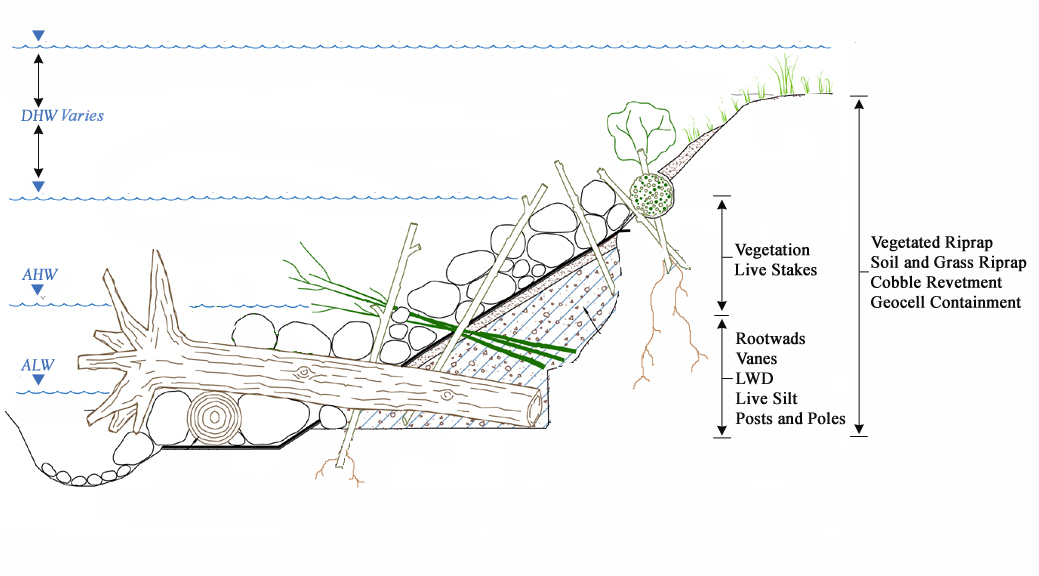
Figure 3. Elevation diagram of DHW, AHW, and ALW
It is important to remember that there is no simple rule for selecting the design storm event. For any revetment technique, the design storm is selected by a combination of experience, local criteria, and policy. For example, in California, bridges on federal and state highways should pass the 50-year storm with sufficient freeboard for debris. Requirements vary by state, region, and municipality. Considerations for selecting the design storm interval for designing revetments are: risk to personal safety, potential loss of roadway fill that could increase travel times and cause accidents, the cost of rebuilding fill, and the availability of suitable rock. (Racin, 2000).
Design storms should be recalculated for a project site periodically based on recent high-water events, damages, and new gage data. Volume and duration of runoff are responses of global and regional weather patterns, which vary and are not easily forecasted. Velocities and flow rates depend directly on land characteristics and usage, which may change frequently in certain regions (Racin, 2000). Because the high flows produced by a design event vary based on the setting of a project site, it is important to note that DHW is not specified in the technique descriptions. Project designers must use local information and standard engineering procedures to determine the extent to which a revetment or similar structure should be built on a given bank.
The same concept of identifying important levels of flow in stream systems is also termed Stream Zonation and is addressed in this manual. In general, ALW refers to the toe zone and AHW is comprised of the toe and splash zones. The bank and top of bank zone is generally included in DHW.
REFERENCES
Andrews, E. D. (1980). Effective and bankfull discharge of streams in the Yampa
Basin, western Wyoming, Journal of Hydrology, 46, 311-330.
Biedenharn, D. S., Copeland, R. R., Thorne, C. R., Soar, P. J., Hey, R. D.,
& Watson, C. C. (2000). Effective Discharge Calculation: A Practical Guide.
Report No. ERDC/CHL TR-00-15, U. S. Army Corps of Engineers, Engineer Research
and Development Center, Vicksburg, MS.(pdf)
Biedenharn, D. S., Thorne, C. R., Soar, P. J., Hey, R. D., & Watson, C. C.
(2001). Effective discharge calculation guide. International Journal of
Sediment Research, 16(4), 445-459.
Boyd, K. F., Doyle, M., & Rotar, M. (2000). Estimation of dominant discharge
in an unstable channel environment. Proc., 1999 International Water Resources
Engineering Conference (CD-Rom), Environmental and Water Resources Institute,
Reston, VA.
Copeland, R. R., McComas, D. N., Thorne, C. R., Soar, P. J., Jonas, M. M.,
and Fripp, J. B. (2001). Hydraulic Design of Stream Restoration Projects.
Technical Report ERDC/CHL TR-01-28, U.S. Army Corps of Engineers: Engineer
Research and Development Center; Vicksburg, MS. (pdf)
Doyle, M. W., Boyd, K. F., and Skidmore, P. B. (1999). River restoration channel
design: back to the basics of dominant discharge. Second International Conference
on National Channel Systems, Ministry of Natural Resources, Ontario, Petersborough,
Ontario. (pdf)
Emmett, W. W. and Wolman, M. G. (2001). Effective discharge and gravel-bed rivers.
Earth Surface Processes and Landforms, 26, 1369-1380.
Federal Interagency Stream Restoration Working Group (FISRWG). (1998). Stream
corridor restoration: principles, processes and practices. National Technical
Information Service, U.S. Department of Commerce, Springfield, VA. (pdf)
Hey, R. D. (1975). Design discharge for natural channels. Science, technology and environmental management, R. D. Hey and T. D. Davies, eds., Saxon House, Farnborough, England, 73–88.
Hey, R. D. (1994). Restoration of gravel-bed rivers: Principles and practice.‘‘Natural’’ channel design: Perspectives and practice, Canadian Water Resources Association, Cambridge, Ont., 157–173.
Jennings, M. E., Thomas, W. O., & Riggs, H. C. (1994). Nationwide Summary of U.S. Geological Survey Regional Regression Equations for Estimating Magnitude and Frequency of Floods for Ungaged Sites, 1993. U.S. Geological Survey Water-Resources Investigations Report 94-4002. Reston, Virginia.
Kondolf, G. M., Smeltzer, M. W., and Railsback, S. F. (2001). Design and performance of a channel reconstruction project in a coastal California gravel-bed stream. Environmental Management, 28(6), 761-776. (pdf)
Leopold, L. B., Wolman, M. G., and Miller, J. P. (1964). Fluvial processes in geomorphology. Freeman, San Francisco.
Ministry of Natural Resources. (1994). Natural channel systems: An approach
to management and design, Queen’s Printer for Canada, Toronto.
Pickup, G. (1976). Adjustment of stream-channel shape to hydrologic regime.
Journal of Hydrology, 30, 365-373.
Racin, J. A., Hoover, T. P., & Crossett Avila, C. M. (2000). California Bank and Shore Rock Slope Protection Design - Practitioner's Guide and Field Evaluations of Riprap Methods. Report number FHWA-CA-TL-95-10, California Department of Transportation. Sacramento, CA.
Riley, A. L. (1998). Restoring streams in cities: A guide for planners, policymakers, and citizens, Island Press, Washington, D.C.
Rosgen, D. L. (1996). Applied river morphology. Wildland Hydrology
Publications, Pagosa Springs, CO.
Schumm, S. A., Harvey, M. D., and Watson, C. C. (1984). Incised channels:
morphology, dynamics and control. Water Resources Publications, Littleton,
CO.
Simon, A. (1989). The discharge of sediment in channelized alluvial streams.
Water Resources Bulletin, 25(6), 1177-1188.
Soar, P. J. (2000). Channel Restoration Design for Meandering Rivers. Unpublished
PhD Thesis, School of Geography, University of Nottingham, Nottingham, U.K.,
409 pp.
Soar, P. J. and Thorne, C. R. (2001). Channel Restoration Design for Meandering
Rivers. ERDC/CHL CR-01-1, U.S. Army Corps of Engineers, Engineer Research
and Development Center, Vicksburg, MS.(pdf)
Thorne, C. R., Allen, R. G., and Simon, A. (1996). Geomorphological river channel
reconnaissance for river analysis, engineering and management. Trans. Inst.
British Geography, 21, 469-483.
Watson, C. C., Dubler, D., and Abt, S. R. (1997). Demonstration erosion control project report: Design hydrology investigations, River and Streams Studies Center, Colorado State University, Fort Collins, CO.
Wharton, G., Arnell, N. W., Gregory, K. J., and Gunnels, A. M. (1989). River
discharge estimated from channel dimensions. J. Hydrol., 106, 365–376.
Williams, G. P. (1978). Bankfull discharge of rivers. Water Resources Research,
14(6), 1141-1480.
Wolman, M. G. and Miller, J. P. (1960). Magnitude and Frequency of Forces in
Geomorphic Processes. Journal of Geology, 68, 54-74.